About Ostfriesland
 Much of Ostfriesland is below or only a few feet above sea-level and dikes were built to claim land from the sea for centuries. The ground is wet and has extensive marsh lands which made travel difficult while the sea presented both a constant threat and economic opportunities to the Friesen "people of the sea". The area was historically dependent on labor-intensive farming, fishing and related activities though Emden had a good harbor that attracted wealthy merchants and robust international trading businesses.
During the ice age, sea levels were much lower and the coast was farther north. As the glaciers melted, the sea level rose and low-lying coastal areas disappeared under the sea. The land became wetter and more land turned into marshes. Thousands of years of vegetation built up thick layers of peat in these areas that was unsuitable for farming but could be used as fuel for warmth and cooking.
Early Roman explorers noted that the Friesens along the coast lived on mounds (warffen) and were surrounded by the sea twice a day as the tides went in and out. The residents ate fish they caught and did not have animals or milk to drink. Many of these mounds had been made by scraping up clay from the tidal areas and they were built higher as the sea rose. As the population grew, these mounds often became the foundation for communities. Clues about the early landscape can be gleaned from maps and satellite images that often show communities clustered in a circle, usually around a church, while others developed in a long line where homes may have been built on the crest of a sandy ridge.
As the population grew, people were increasingly pushed into the unfarmed marshlands. The early settlers, known as colonists, had very difficult lives as they had to cut the peat from their land to reach the clay soil below so they could begin to grow grain. Canals had to be dug to transport the peat and help drain the land. As the land was drained, the peat shrunk as it dried and the land settled closer to sea level or below, increasing flooding risks from storms on the North Sea.
 Some of the North Sea storms were basically hurricanes with high winds that drove storms surges to dangerous levels. The tides attacked the dikes and pushed flooding far inland as it backed up in streams and rivers. In some cases, the water pushed under the peat and floated it as islands over the underlying clay surfaces. A severe storm created the Dollart Bay in 1277 and many communities were lost to the flooding. History has recorded many of these floods and the OGSA has translated a book, "Storm Floods - 1,000 Years of Catastrophic Floods on the Ostfriesen Coast" which is available for researchers interested in this topic in our online store.
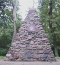 The Ostfriesens were fiercely independent as noted in the motto on their coat of arms. The greeting, "Eala Freya Fresena" ("Hail [or Stand] Free Frisian!"), was used at the Upstalsboom near Rahe in medieval times when local chieftains met there on the first Tuesday after Pentecost. The answer given was “Lever Dood As Slav” (rather dead than a slave). The motto refers to the legendary "Frisian Freedom", the right of the Frisian to accept no rule other than that of the Holy Roman Emperor and the Christian God.